The topics for #30dayMapChallenge 2021 were:

As a die hard user of FME from (Safe Software),what could be a better opportunity to put my FME skills to test!
This post is a collection of all entries for #30DayMapChallenge 2021 by @Saint_GIS, most of which have been accomplished only using FME and in few cases, due to the nature of the challenge, the data prepared using FME.
Happy FME-ing :-) reading my #30DayMapChallenge 2021 entries!
Day 1: Points
First entry for the #30DayMapChallenge 2021- 101 Random Points generated using FME from Safe Software

Another entry for Day 1 Points-Some places (Points) with population more than 1.5 million generated using FME from Safe Software

Day 2: Lines
NH548: Shortest National Highways in India (Length 5Km (3 miles)
Data prepared using FME from Safe Software

Day 3: Polygons
World Countries by Sovereignty (Sovereignty represented through Concave Hull Polygons) using FME from Safe Software

Day 4: Hexagons
Our World as Hexagons using FME from Safe Software

Day 5: Data challenge 1: OpenStreetMap
OpenStreetMap extract for a part of Chennai City rendered using MapnikRasterizer in FME from Safe Software

Day 6: Red
Infant Mortality Rate per 1000 Live Births (2018) rendered using MapnikRasterizer in FME from Safe Software

Day 7: Green
Map of National Trees of Some Countries rendered using MapnikRasterizer in FME from Safe Software

Day 8: Blue
Global Lakes (area ≥ 50 km2) and Reservoirs (storage capacity ≥ 0.5 km3) rendered using MapnikRasterizer in FME from Safe Software

Day 9: Monochrome
OpenStreetMap extract for a part of #Chennai City rendered in Monochrome using MapnikRasterizer in FME from Safe Software

Day 10: Raster
World Map with Flags of Countries as Collage using MapnikRasterizer in FME from Safe Software

Day 11: 3D
3D of Tirumala and environs
https://en.wikipedia.org/wiki/Tirumala
Coordinates: 13.680916°N 79.350600°E
Map generated using FME from SafeSoftware and visualized using Google Earth

Day 12: Population
Population Density (2020) of World Countries
Map generated using MapnikRasterizer in FME from Safe Software

Day 13:Data Challenge 2: Natural Earth
World Countries Color Coded by Time Zone (UTC Offset)
Map generated using MapnikRasterizer in FME from Safe Software

Day 14:New Tool
World Countries in 62,004 points Color Coded by Continent using Kepler.gl
Point data generated using FME from Safe Software


Day 15:Map made without using a computer
Inspired by my endless love for FME from Safe Software and my favourite entry
Map of the City of FME data expressways, XML park formats lake, data mountains, data type buildings and the lovely FME Central!

Day 16: Urban/Rural World Countries with Urban Population >=75% of its total population (2018)
Map generated using MapnikRasterizer in FME from Safe Software

Day 17:Land
Largest Countries in the World (by area)
Land Area more than or equal to 1% of World Land Mass
Map generated using MapnikRasterizer in FME from Safe Software

Day 18:Water
World Countries and their Water Stress (2018)
Some Countries with Water Stress >=100%
Map generated using MapnikRasterizer in FME from Safe Software

Day 19:Islands
Andrott and Bitra Islands,Lakshadweep,India
Map generated using MapnikRasterizer in FME from Safe Software

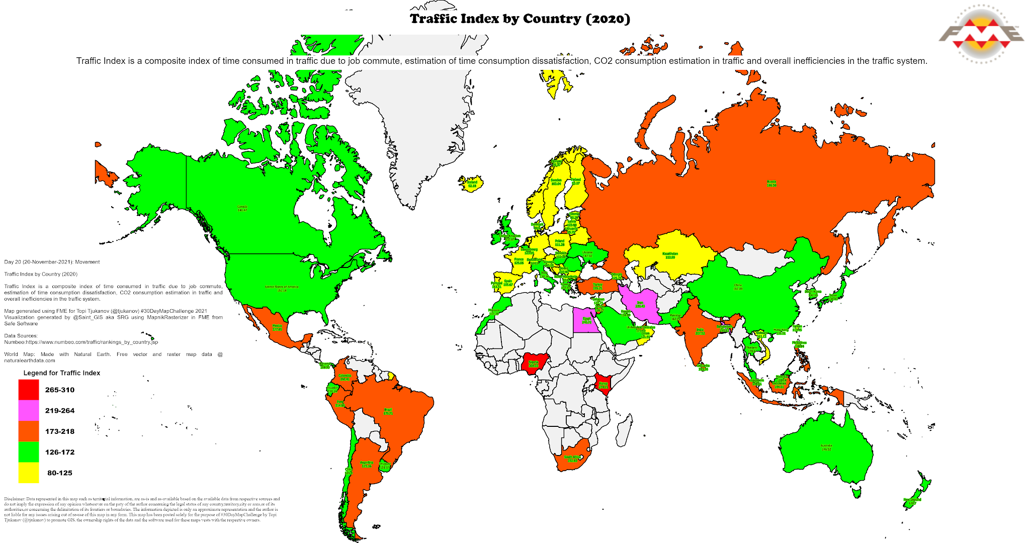
Day 20:Movement
Traffic Index by Country (2020)
Map generated using MapnikRasterizer in FME from Safe Software
Day 21:Elevation
Indian States and UTs by Highest Point
Map generated using MapnikRasterizer in FME from Safe Software

Day 22:Boundaries
Maritime Boundaries: Territorial Seas (12NM)
Map generated using MapnikRasterizer in FME from Safe Software

Day 23:Data Challenge 3: GHSL Global Human Settlement Layer
GHS Functional Urban Areas (GHS-FUA)
Map generated using MapnikRasterizer in FME from Safe Software

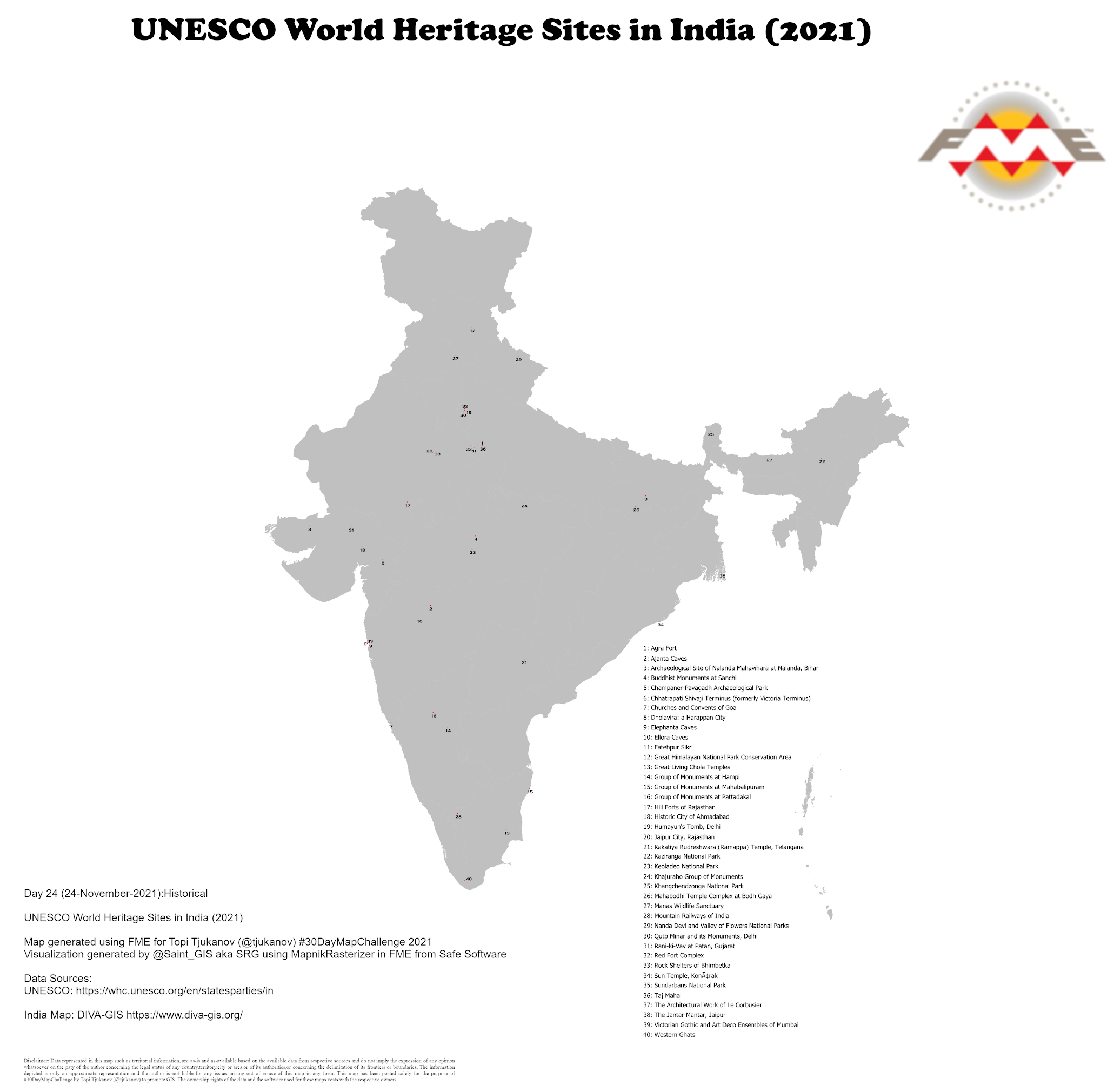
Day 24:Historical
UNESCO World Heritages Sites in India 2021
Map generated using MapnikRasterizer in FME from Safe Software
Day 25:Interactive
World Countries and Urban #Population 2018
GeoJSON for map generated using FME from Safe Software
Visualization using Unfolded Studio
Click here for the interactive map

Day 26:Choropleth
Worldwide Estimated Cancer Deaths (2020)
Map generated using MapnikRasterizer in FME from Safe Software

Day 27:Heatmap
Annual Mean Temperature °C (1991-2020)
Map generated using MapnikRasterizer in FME from Safe Software
The heatmap effect has been achieved using GradedColorizer transformer in FME

Day 28: Earth is not Flat
Earth is not flat and that is why we have this completely FME (from Safe Software) generated 3D Globe
Original workspace of Dmitri Bagh of Safe Software adapted with changes
And for those interested in juggling around with the actual 3D PDF in Adobe Reader, click here

Day 29:Null
World Map in Null generated using MapnikRasterizer in FME from Safe Software

Day 30: Metamapping That is why, this blog post!
The #30DayMapChallenge 2021 entries are also available on Flickr
It may be 30 days of gruelling, brainstorming; putting all your learning and experience into practice or self test To me, the whole idea of participating and contributing to #30DayMapChallenge 2021 is about promoting #GIS
But then the satisfaction in having contributed to promotion of GIS outweighs everything else!
GIS Temper, Let us not lose it!
I take this opportunity to thank all those who contributed in some way or the other, to my career and to what I am today in the field of GIS!
Thanks to Safe Software for such a wonderful product/platform "FME" that helped me to convert,transform,share and integrate data from multi-farious sources and types, not just for this #30DayMapChallenge 2021, but for the last 21 years of my career in GIS
Last but not the least, special thanks to my family (my wife and son) for all the patience, understanding and support, while I meticulously worked on the submission every day!
More information about Topi Tjukanov (#30DayMapChallenge conceptualizer) https://medium.com/@tjukanov
https://twitter.com/tjukanov


No comments:
Post a Comment