The topics for #30dayMapChallenge 2022 were:

As a die hard user of FME from (Safe Software),what could be a better opportunity to put my FME skills to test!
I have been participating in #30DayMapChallenge @tjukanov since 2019.
Since 2020, I have been able to post an entry on all the 30 days of #30DayMapChallenge.
And that calls for a celebration! because it is a hat-trick.
This post is a collection of all entries for #30DayMapChallenge 2022 by @Saint_GIS, most of which have been accomplished only using FME and in few cases, due to the nature of the challenge, the data prepared using FME.
Some entries additionally have their #FMEAR Augmented Reality versions as well.
Special thanks to Dmitri Bagh and Lena Bagh at Safe Software for all the inspiration!
Happy FME-ing :-) reading my #30DayMapChallenge 2022 entries!
Day 1: Points
First entry for the #30DayMapChallenge 2022- Some places (Points) with population more than 1.5 million generated using FME from Safe Software

Day 2: Lines
NH548 and NH118 are supposed to be the two shortest National Highway in #India 5 Km (3.1 mi)
Data prepared using FME from Safe Software.
Additionally here is a #FMEAR version of this post
Day 3: Polygons
World Countries by Sovereignty (Sovereignty represented through Concave Hull Polygons) using FME from Safe Software

Day 4: Green
Map of National Trees of Some Countries rendered using MapnikRasterizer in FME from Safe Software

Day 5: Ukraine
3D map of Mt Hoverla in Ukraine generated using FME from Safe Software

Day 6: Network
3D Visualization of Traffic Signals Network from OpenStreetMap for Chennai using MapnikRasterizer in FME from Safe Software

Day 7: Raster
DEM Raster visualization of Mt Hoverla in Ukraine using MapnikRasterizer in FME from Safe Software

Day 8: Data: OSM
Restaurants in Chennai within 50m from certain OSM Highway types using MapnikRasterizer in FME from Safe Software

Day 9: Space (space: a place or an area that is empty or not used)
Devon Island, Canada: The largest uninhabited island in the world
Visualization generated using FME from Safe Software

Day 10: A Bad Map
Top 5 Countries by Crime Rate (2022) using MapnikRasterizer in FME from Safe Software


Day 11: Colour Friday: Red

Day 12: Scale

Day 10: A Bad Map
Top 5 Countries by Crime Rate (2022) using MapnikRasterizer in FME from Safe Software

Another entry for (An Intentionally) Bad Map
For some fun, World Map with Countries Offset Randomly in X & Y Direction from their Original Location using custom FME Workspace.
(Original position shown in black outline without fill)

Day 11: Colour Friday: Red
Infant Mortality Rate >=10 per 1000 Live Births (2020)
Map generated using MapnikRasterizer in FME from Safe Software
Day 12: Scale
Map to Demonstrate the Significance of Scale
Africa Continent Administrative Boundaries at 1:10 million and 1:110 million Scale overlaid using FME from Safe Software
Map generated using MapnikRasterizer in FME from Safe SoftwareBoundaries in Red at 1:110 million scale (Small Scale=Less details)
Boundaries in Black at 1:10 million scale (Large Scale=More details)

Day 13:A 5 minute map

Day 14:Hexagons

Day 15:Food/Drink

Day 16: Minimal

Day 13:A 5 minute map
Map to Demonstrate the Speed of Data Integration using FME from Safe Software with MapnikRasterizer and MapTextLabeller
OpenStreetMap of Chennai with Road Names replaced with some formats supported by FME 2022
Map generated using MapnikRasterizer in FME from Safe Software

Day 14:Hexagons
Our World in 112,269 Hexagons generated using FME from Safe Software and QGIS

Day 15:Food/Drink
National Food (Official/Unofficial) of some countries
Visualization generated using MapnikRasterizer in FME from Safe Software

Day 16: Minimal
The Republic of #Nauru (Pleasant Island), Smallest Island Nation
Map generated using FME from Safe Software

Day 17:Map without a computer

Day 18: Colour Friday: Blue
Day 19:Globe

Day 20:My Favourite: Human Development Index (2022)
Map generated using FME from Safe Software

Day 17:Map without a computer
A hand drawn sketch map of the neighborhood of a die hard #FME fan, FME user, FME Certified Professional & Trainer, FME Server Certified Professional and FME Business Certified Professional

Day 18: Colour Friday: Blue
Global Lakes (area ≥ 50 km2) and Reservoirs (storage capacity ≥ 0.5 km3)
Visualization generated using MapnikRasterizer in FME from Safe Software

Day 19:Globe
Earth is not flat and that is why we have this completely FME from Safe Software
3D globe generated using Dmitri Bagh's (Safe Software) original workspace with changes

Day 20:My Favourite: Human Development Index (2022)
Human Development Index (2022) of some Countries
Map generated using MapnikRasterizer in FME from Safe Software
Day 21:Data Kontur Population Dataset
(Global Population Density for 400m H3 Hexagons)
400m hexagon grid with population >=5000 #TamilNadu #India
Hexagons in red means population >=5000
Map generated using MapnikRasterizer in FME from Safe Software

Day 22:Null
World Map using 82,922 "NULL" text string
Map generated using MapnikRasterizer in FME from Safe Software

Day 23:Movement
Traffic Index of some Countries (2022)
Map generated using MapnikRasterizer in FME from Safe Software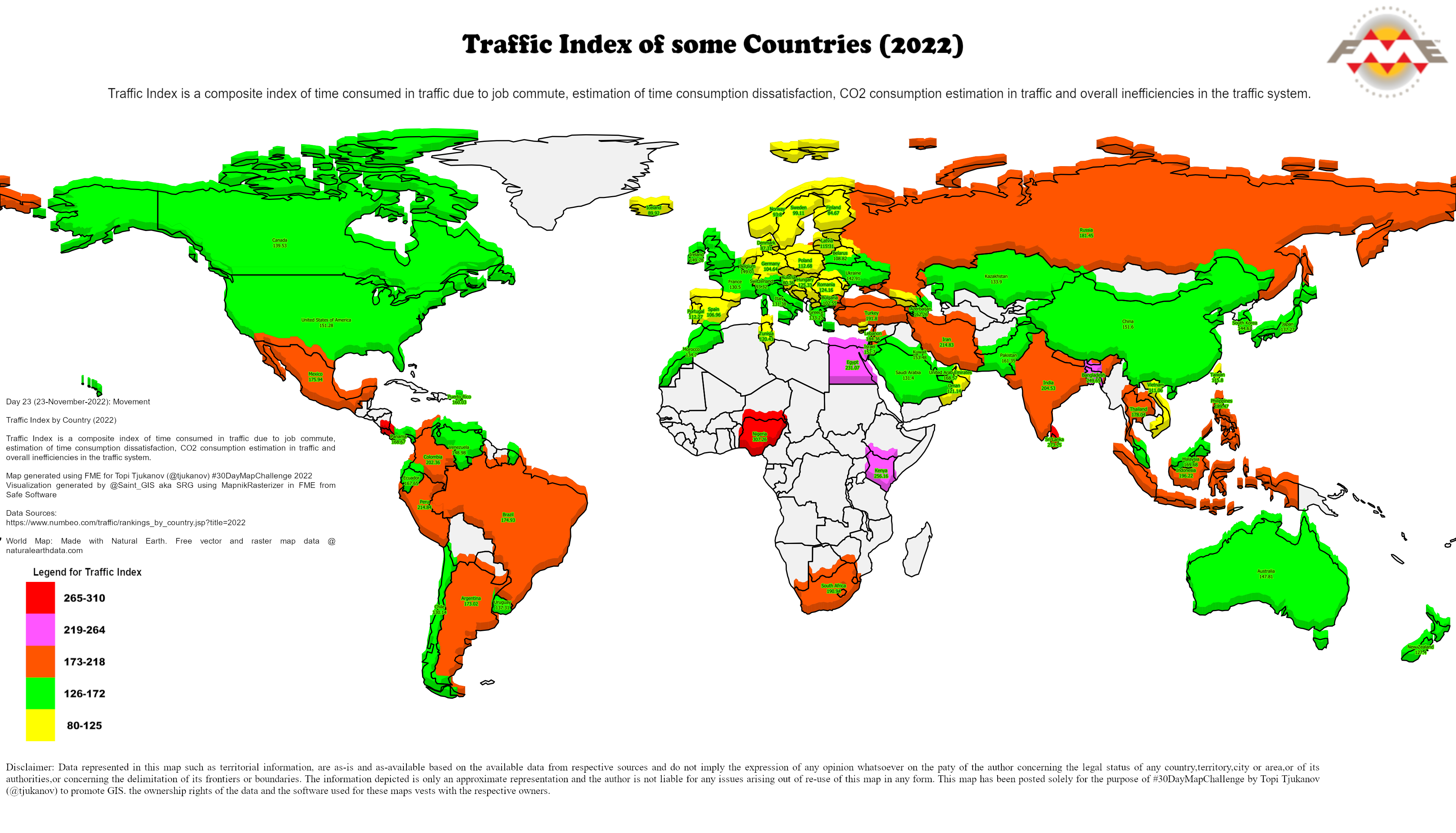
Day 24:Fantasy
The Fantasy World of FME Lizards and FME Zipsters FME Lizard
Fantasy map completely generated using MapnikRasterizer in FME from Safe Software

Day 25:Colour Friday-2 Colours
Some countries with bicolour flag Day 26:Choropleth
Worldwide Estimated Cancer Deaths (2020)
Map generated using MapnikRasterizer in FME from Safe Software

Day 26:Island(s)
Flevopolder, The Netherlands
Largest man-made island
Map generated using MapnikRasterizer in FME from Safe Software

Day 27:Music
National Music Instruments of Some Countries
(Official & Unofficial)
Map generated using MapnikRasterizer in FME from Safe Software
Day 28:3D
3D view of Kotagiri in The Nilgiris, India
3D Map generated using #FME from Safe Software

Day 29:Out of my comfort zone
Life Expectancy at Birth in Years (2019) for some Countries
Visualization using Qlik Sense Desktop from Qlik
Data loading and data preparation using FME from Safe Software

Day 30: Remix
A newer versionof a map that I had done during the #30DayMapChallenge 2022 or a map done by someone else and do your own version.I wanted to post on the dangers of climate change on atleast one of the #30DayMapChallenge days.
I was planning to do a 3D on Day 28 using #MapnikRasterizer
But finally got to do it on Day 30:Remix
Kind of 3D visualization effect using MapnikRasterizer in FME from Safe Software

It may be 30 days of gruelling, brainstorming; putting all your learning and experience into practice or self test To me, the whole idea of participating and contributing to #30DayMapChallenge 2022 is about promoting #GIS
But then the satisfaction in having contributed to promotion of GIS outweighs everything else!
GIS Temper, Let us not lose it!
I take this opportunity to thank all those who contributed in some way or the other, to my career and to what I am today in the field of GIS!
Thanks to Safe Software for such a wonderful product/platform "FME" that helped me to convert,transform,share and integrate data from multi-farious sources and types, not just for this #30DayMapChallenge 2022, but for the last 22 years of my career in GIS
Last but not the least, special thanks to my family (my wife and son) for all the patience, understanding and support, while I meticulously worked on the submission every day!
More information about Topi Tjukanov (#30DayMapChallenge conceptualizer) https://medium.com/@tjukanov
https://twitter.com/tjukanov


No comments:
Post a Comment